|
Early History
Ridge House
The Gardens
Ridge Families
Topography
Maps
Time Tour
Picture Gallery
|
|
 |
| |
In Ancient Days
From the earliest times, this ridge of high land has been important for the people who have lived here. Consisting of carboniferous limestone, its southernmost point lies at the heart of Chipping Sodbury - the land begins to rise on the opposite side of the road to the clock tower. It continues north towards Wickwar, and many interesting features can be discovered along its length.
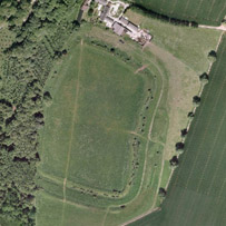 It seems that a number of camps were established along The Ridge during the Iron Age (hill forts first began to appear in England from around 1000 BC). The picture shows such an example of nearby Sodbury hillfort. It seems that a number of camps were established along The Ridge during the Iron Age (hill forts first began to appear in England from around 1000 BC). The picture shows such an example of nearby Sodbury hillfort.
Towards the northernmost edge of this high ground, Bury Hill commands a view westwards towards the River Severn. The place-name 'Bury' usually indicates a hill fortification and although small-scale mining has obliterated much of the evidence, it is still possible to discern the markings of encircling ditches culminating in a mound at the hill's summit.
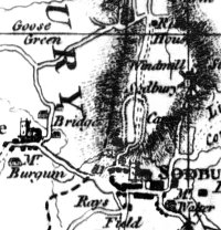 On Isaac Taylor's map of 1777, we find that a camp stood in RidgeWood, close to the site now occupied by Hanson's headquarters. Its position is interesting as it appears to line up with the Little Sodbury camp that can be found on the Cotswold edge to the east of our area. So from its earliest days, the height of The Ridge was exploited, certainly for defensive purposes. On Isaac Taylor's map of 1777, we find that a camp stood in RidgeWood, close to the site now occupied by Hanson's headquarters. Its position is interesting as it appears to line up with the Little Sodbury camp that can be found on the Cotswold edge to the east of our area. So from its earliest days, the height of The Ridge was exploited, certainly for defensive purposes.
Because good visibility was obviously the main requirement for such a camp, it would seem that certainly the summit of The Ridge was at this time fairly open in character - it could be that our Celtic ancestors were responsible for clearing the trees and opening up the view.
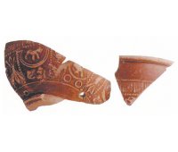
The Romans were also active in this area. In ?Part of the Continuing Story of the Sodburys?, the local historian Percy Couzens, describes how shards of Roman pottery were discovered at the quarry of Messrs Wilson and Turner which was situated about a mile from Chipping Sodbury, along the line of The Ridge. The remains were identified as Samian Ware.
 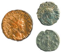
A large number of Roman coins were found with other remains at Hall End Farm, another settlement established on The Ridge. These finds were made during the time that the area was being mined for the rare mineral celestine. In his book ?The Three Sodburys?, Gordon Tily suggests that this particular site may have once been occupied by an inn serving the Roman road between Bath and Aust.
Anglo-Saxon and Medieval Times
Yate can be traced back to the Anglo Saxon era. There is much speculation about the origin of this place name. It may have derived from the word 'yat', which indicates an area of high ground - as in the lofty Symonds Yat in the Wye Valley. This would perfectly describe The Ridge in its position at the edge of the settlement Alternatively, it may derive from the word 'gaet', indicating a gate.
For centuries, the royal Kingswood Forest dominated the South Gloucestershire landscape. Yate marked its north-easterly extent. It is therefore possible that it served as a gateway to the forest land.
The Ridgewood Centre originally served as Chipping Sodbury's workhouse. Until well into the 20th century, a huge hollow oak stood next to it. It was used by tramps to store their possessions before entering the confines of the workhouse. A local legend refers to this oak as the very last tree of the great Kingswood Forest. As oaks are renowned for their longevity, there could be some truth in this tale!
In medieval times, The Ridge is believed to have belonged to the manor of Stanshawes.
It seems that throughout its history, this area has been valued as a source of limestone. Local residents will be familiar with the vast Barnhill Quarry but small-scale quarrying is a long-standing feature of The Ridge and its surrounds. It is well worth visiting the settlement of Yate Rocks which lies just south of Bury Hill - the appearance of this quiet hamlet owes much to this activity. Many of its beautiful old cottages shelter in quarried hollows, their steep rock faces still evident.
The Ridings
This area runs parallel with The Ridge and, like its neighbour, also occupies high ground. It has an interesting history. Nowadays, it consists of large open fields which are used for sports such as golf and cricket, and it is a breezy, exhilarating place to visit. To the west, the wooded slopes of The Ridge dominate the horizon whilst a mile or so to the east, the Cotswold edge rises - here, the hillfort at Little Sodbury looms across the land.
The origin of The Ridings is not fully understood but local historians have noted that its name may have Danish roots, and be akin to the Ridings in Yorkshire. The latter area was part of the Danelaw before the Norman Conquest. A 'riding' is a division of land which can be translated as 'thirdings' or third parts. Chipping Sodbury and Yate were once part of the Saxon kingdom of Mercia, which, for a while, came under the control of the Danes.
However, our knowledge of The Ridings increases as we look at the records belonging to later centuries. The borough of Chipping Sodbury was created in the 12th Century by William Crassus. As a commercial centre, the inhabitants dwelt in their burgage plots - parcels of land whose outlines can still be traced today as they flank the main street running through the town.
However, these tradesmen had no land to graze their beasts of burden - which in those days, of course, provided the only real means of commercial transport. So The Ridings became the borough's common grazing ground.
The bailiff was responsible for allocating grazing and hay rights to the inhabitants, who had to satisfy various criteria which focussed on the length of time they had dwelt in the borough. Animals were grazed on the Stub Riding between late May and late August and then turned on to the Mead Riding after its crops had been gathered. The livestock could stay there until December after which time the land became common to everyone for a few weeks.
There was also some quarrying on The Ridings and at one time, a pest house stood there. Those with infectious diseases were nursed in this building, well away from the other residents of the town. It was also used as a setting for fairs and celebrations of national events - and this tradition continues today.
Local people enjoyed their grazing rights on The Ridings until the 20th century. Nowadays, as a venue for sports and local festivities, it continues to serves as a piece of land set apart for the community.
Thanks to Sharon Eubank
Return to top of page
|
|
| |
|