|
Early History
Ridge House
The Gardens
Ridge Families
Topography
Maps
Time Tour
Picture Gallery
|
|
 |
| |
An Analysis of the Historical Topography of Ridge Wood, Yate
by Mike Chapman (Avon Gardens Trust)
The site is discussed the under the following headings:
1. General historical development
2. Physical remains of individual historical features
3. Possible future lines of enquiry
Historically, the study area mainly consisted of the Ridge House Estate which covered the central and northern section of the wood, together with a large part of the area on the west side now occupied by modern housing.
The southern section of the wood consisted of several grounds, the largest of which, at the extreme southern end known as Barn Hill, belonged to the Dodington estate.
1. Historical Development
Three phases of development of Ridge House Estate can be identified:
Phase 1: c.1800
The exact date of the establishment of Ridge House and its grounds is still unclear. It is not shown on Taylor’s map of Gloucestershire (1777) but was certainly in existence by 1813. Plans of Barn Hill drawn up that year for Christopher Codrington of Dodington show that the adjoining land to the north was already in the possession of James Bradshaw, landowner of the Ridge House estate as it appears in the tithe apportionment of 1839.
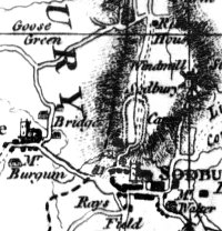
The estate is first shown on the county maps of Greenwood (1823), Bryant (1824) and the OS 1-inch survey (late 1820s) which, despite their small scale, provide some significant details not found elsewhere. All these sources agree that, on the summit of the ridge, the entrance drive from Station Road did not originally approach the house on the east side, but followed the line of the present avenue of Sequoiadendron giganteum (Wellingtonias) on the west side, before terminating between the house and the kitchen garden. Not far from the road entrance, the drive is also shown passing through a clump of trees, the remains of which still stand at the back of Broadway Infants’ School. Although the driveway is not depicted on the tithe map, from the apportionment it can be seen that, below the ridge, its tortuous route was dictated by the scattered layout of the fields which belonged to the house on the west side. No access was then possible from the Wickwar Road, for example, as the intervening fields were in separate ownership.
The tithe map also shows that Ridge House was originally much smaller than the structure shown on maps and photographs from the 1880s onward. Together with the ‘pleasure ground’, kitchen garden and ‘Barton and outbuildings’ adjoining the house, the estate would appear to have been a typical gentleman’s ‘ornamental farm’ (ferme ornée) of the early 1800s. The house would have been self-supporting from its attached land (about 501/2 acres in total) which is why, in the census returns between 1841-1861, its occupiers (all apparently leaseholders) are generally classified as ‘farmers’.
Most of this territory was then open grass pastureland with occasional patches of cultivation. The field names (frequently called ‘Upfield’, and ‘Leaze’), together with the scattered ownership pattern, suggests that they were enclosed out of the former common field system of Yate. 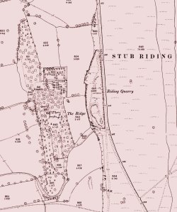 Only at the northern end of the Ridge House grounds was there a small wood, ‘Ridge Brake’ (3/4 acre) which is shown prominently on the county maps, perhaps with a round covert just above it on the top of the ridge. Also, the slope on the west side of the house was not originally fenced, as today, but ran out into the field called ‘Ridge’, all of which was probably dotted with standard trees in the fashion of landscaped parkland. In the next field the tithe map shows a building described as a ‘Homestead, Oxpen and Barton’ situated next to a spring which ran across the field (appropriately named ‘Rushy Leaze’) towards the river Frome. However no other indication has been found that this building served as a habitation. There was also a ‘Barn, garden &c’ between the road entrance and Firgrove House, but no lodge. Only at the northern end of the Ridge House grounds was there a small wood, ‘Ridge Brake’ (3/4 acre) which is shown prominently on the county maps, perhaps with a round covert just above it on the top of the ridge. Also, the slope on the west side of the house was not originally fenced, as today, but ran out into the field called ‘Ridge’, all of which was probably dotted with standard trees in the fashion of landscaped parkland. In the next field the tithe map shows a building described as a ‘Homestead, Oxpen and Barton’ situated next to a spring which ran across the field (appropriately named ‘Rushy Leaze’) towards the river Frome. However no other indication has been found that this building served as a habitation. There was also a ‘Barn, garden &c’ between the road entrance and Firgrove House, but no lodge.
Although there is some evidence of quarrying along the Ridge in earlier times, there are few signs of activity in the early 19th century. However, the limekiln sited just below the house may have still been in use at this time. There appear also to have been other limekilns further north, as indicated by ‘Lime Croft’ and ‘Kiln Leaze’ fields between the Wickwar Road and Love Lane. Cheap small coal was readily available from the nearby Yate collieries on Engine Common, and the tithe map shows a coal yard owned by the colliery owner Joseph Staley next to the present Chipping Sodbury Clinic - only a few yards from the driveway entrance. Nevertheless these kilns probably only produced lime for private use (for building maintenance and as a fertiliser) rather than on a commercial basis – large-scale lime production was only carried on by the Yate Collieries.
Nor is there any indication of a quarry on Barn Hill at the southern end of the ridge at this stage. Curiously, the Dodington plans show that at some time between 1771 and 1813 an avenue of trees was laid out along the top of the ridge here. The rationale for this feature (which also appears on the OS 1 inch map) is not immediately obvious, nor is there any evident relationship with Ridge House. Also visible on the plans (and on the tithe map) is the barn that gave this part of the ridge its name and stood approximately on the site of the present B.Q.C.substation at the southern entrance to Barn Hill Quarry. Further north, there were two strips of ground separated by gulleys running down the slope. One of these, belonging to the parish glebe, narrowed to a strip about 30 feet wide at the base of the slope, as can be seen next to the driveway to Ridge House where the old hedge banks are still visible. At some earlier period this may have provided a droveway ‘funnel’ for livestock descending from the Sodbury Ridings to the lower lands in Yate, a feature which is frequently found on the scarps below the upland sheep pastures of the Cotswolds and the Mendips.
Phase 2: c.1865
Some time after 1861, but before Edward Burges took possession of the Ridge House estate in 1868, extensive (and expensive) alterations and improvements were made to both the house and the grounds, as revealed on the OS 25 inch map of 1881. These changes included the following:
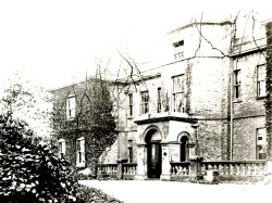 1. The old house, constructed of coursed rubble, was enlarged by the addition of new ashlar-faced wings on the east and west sides, with an arched porch attached to the stair turret on the north elevation. A balustrade which surrounded most of the old house was removed except for the space between the two wings and the porch on the north side, visible on the old photograph. A large glass conservatory or orangery was also attached to the west side of the house. 1. The old house, constructed of coursed rubble, was enlarged by the addition of new ashlar-faced wings on the east and west sides, with an arched porch attached to the stair turret on the north elevation. A balustrade which surrounded most of the old house was removed except for the space between the two wings and the porch on the north side, visible on the old photograph. A large glass conservatory or orangery was also attached to the west side of the house.
2. The driveway was diverted to the east side of the house, approximately on its present line. This was probably arranged to join up with a new entrance which had also been opened up from the Wickwar road, next to ‘Riding Quarry’. A narrow strip of land (about a third of an acre) was acquired from the glebeland mentioned above to bring the new driveway in from the road. There are indications that the land belonging to the estate had been increased by about 10 acres by the 1850s, but this extra acreage is now difficult to identify and may only refer to odd pieces of ground (such as the new driveway) rather than extra farm land.
3. The avenue of Wellingtonias was presumably planted at about this time, but whether this was before the driveway alterations were made is not clear. The northern end of the old driveway, across the lawn next to the conservatory, seems to have been retained to give pedestrian access from the rear of the house to the avenue via an ornamental wrought-iron garden gate, as shown and on the 1912 postcard view of the house from the south. The map suggests that the amount of tree cover along the ridge had increased, and that a woodland landscape was being created by the plantation of more trees.
3. The Gardener’s Lodge at the Station Road entrance was built at this time, and appears in the Census return for 1871. A wrought-iron park fence was also extended out along the north side of the driveway through the fields as far as the Lodge, where portions of the fence railings can still be seen at the back and side of the building. The line of walnut trees may have been planted along the fence at this time.
By this time quarrying on Barn Hill was well in progress, and the avenue of trees there had already disappeared.
Phase 3: c.1890s
Between 1881 and 1902 many minor improvements were carried out in the grounds of Ridge House, including;
1. The wrought-iron rail fence was extended along the base of the ridge, separating the slope from the adjoining field. Much of this fence still remains and continues to function as the boundary with the housing estate - between the wooden fencing at the rear of Melrose Avenue and Walnut Avenue.
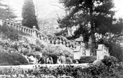 2. Various small buildings were built, including an extension on the east side of the house, together with structure of unknown function in the garden on the north west side of the conservatory. By this time the terrace steps shown on the old postcard had been installed on the west side of the house. A comparison between the pillars in this photograph and those shown on the photograph of the north front suggests that the steps may have been constructed from the old balustrade that encircled the original house. Just behind the steps in the photograph, the gable of a summerhouse or similar building can be made out. This seems to have replaced a smaller structure nearby which is shown on the 1881 map. 2. Various small buildings were built, including an extension on the east side of the house, together with structure of unknown function in the garden on the north west side of the conservatory. By this time the terrace steps shown on the old postcard had been installed on the west side of the house. A comparison between the pillars in this photograph and those shown on the photograph of the north front suggests that the steps may have been constructed from the old balustrade that encircled the original house. Just behind the steps in the photograph, the gable of a summerhouse or similar building can be made out. This seems to have replaced a smaller structure nearby which is shown on the 1881 map.
3. Adjoining the summer house mentioned above was a footpath which led from the west end of the house, via an embankment down the slope, across the fields towards the ‘homestead, oxpen and barton’ in Rushy Leaze. By 1902 the pathway seems to have fallen out of use and from hereon is merely indicated as a field boundary.
4. By 1881 the ‘Old’ limekiln had been long out of use, together with the quarry nearby (judging from the age of the ornamental yew standing in it today), but a building of some size was built at the eastern edge of the quarry between 1881 and 1902. Presumably this was a barn or similar functional building, but nothing remains of it today except for small heap of rubble. The ‘farm barton’ to the north of the house that presumably housed the stables and carriage-sheds (Edward Burges employed three grooms) was progressively extended, and between 1902-15 a large barn or workshop was erected on the north side of the kitchen garden. Also by this date, what appears to be a large duckpond on the south side of the stables was removed, possibly as a result of improved water supply and drainage arrangements. Evidently the house was well supplied from its own well spring, and there were at least two other pumps nearby, one by the stables and another in the kitchen garden.
5. Between 1902 and 1915 a lodge was erected just inside the Wickwar Road entrance.
No further alterations of any consequence seem to have occurred until after the Second World War, these being brought about as a result of the expansion of the Barn Hill quarry workings. The Wickwar Road entrance was destroyed and temporarily replaced by another further north, which led in via the kitchen garden. An agreement must also have been reached at about the same time for the present trackway from Quarry Road to be put through the Barn Hill property.
2. Historical Features
The ‘Haha’
 The remains of the revetted bank or Haha in front of the upper carpark originally constituted the southern boundary of a raised platform which extended out from the back of Ridge House. On the west side the platform turns back along the scarp overlooking the Avenue of Wellingtonias, but the maps show that the Haha also returned along the east side, roughly following the edge of the present driveway. The earliest maps suggest that this area was originally covered with ornamental shrubbery, with pathways running around the perimeter. As the landscape at that time was more open, there must have been good views from this point, particularly to the west. By 1881 however, it had already been converted to a woodland glade with appropriate ground flora, much as can still be seen in the strip which survives on the west side of the car park. The remains of the revetted bank or Haha in front of the upper carpark originally constituted the southern boundary of a raised platform which extended out from the back of Ridge House. On the west side the platform turns back along the scarp overlooking the Avenue of Wellingtonias, but the maps show that the Haha also returned along the east side, roughly following the edge of the present driveway. The earliest maps suggest that this area was originally covered with ornamental shrubbery, with pathways running around the perimeter. As the landscape at that time was more open, there must have been good views from this point, particularly to the west. By 1881 however, it had already been converted to a woodland glade with appropriate ground flora, much as can still be seen in the strip which survives on the west side of the car park.
The Avenue of Wellingtonias
 The original driveway into this avenue appears to have deviated from the present road at about the same point that the new ‘upper’ woodland path begins, about 25 yards in front of the entrance to the upper ARC car park. The avenue itself appears to be situated along what was once a straight flat terrace artificially cut out of the hillside by early quarry workings. Unfortunately this is now difficult to visualise, as the ground has been much disturbed here (probably in quite recent times) with a large amounts of dumped quarry waste. The Wellingtonias are evidently a later addition to the estate, and it is possible that an earlier avenue of native trees originally lined this section of the original driveway. A more detailed botanical inspection of this area might throw more light in these developments. The original driveway into this avenue appears to have deviated from the present road at about the same point that the new ‘upper’ woodland path begins, about 25 yards in front of the entrance to the upper ARC car park. The avenue itself appears to be situated along what was once a straight flat terrace artificially cut out of the hillside by early quarry workings. Unfortunately this is now difficult to visualise, as the ground has been much disturbed here (probably in quite recent times) with a large amounts of dumped quarry waste. The Wellingtonias are evidently a later addition to the estate, and it is possible that an earlier avenue of native trees originally lined this section of the original driveway. A more detailed botanical inspection of this area might throw more light in these developments.
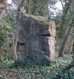 The Standing Stone The Standing Stone
This may have been an original garden feature, as quarry debris was often used for picturesque effect in garden landscapes. It also stands at a significant point at the end of the avenue which, as noted above, would have served as a gateway between the lawns and the woodland area. The ornamental wrought-iron gate has disappeared, but the Haha which stood each side of it still remains.
The Pathway to Rushy Leaze
This feature can still be identified today as a causeway (with signs of a stone revetment on one side) running obliquely down to the new plantation behind the housing estate. The upper footpath crosses it by means of a series of steps. At some stage it was adapted for use to carry a buried sewage pipe, and is now marked by a series of three inspection covers.
Site of the Terrace Steps
Although the steps and rockery shown in the old photograph have disappeared, its site is still identifiable from the lower terraced footpath below the new office complex, and there is still some of the old stonework still protruding through the turf bank.
The Old Quarry
This feature is now difficult to recognise except for an ornamental yew planted in its base. It was originally somewhat larger than today and extended a little way out into the field. It was never railed off by the park fence and served as an entrance into the field for a footpath (now occupied by the small blockhouse or transformer station[?]) which descended from the region of the kitchen garden, below the lower car park. This is the reason for the awkward angle where the footpath negotiates the wooden fencing at the back of Walnut Avenue.
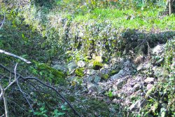
The Old Limekiln
This feature, which stood on the slope on the opposite side of the kitchen garden footpath, is also difficult to recognise. It now appears to consist merely of a pile of rubble and tree roots, although the lower courses of its curved wall still show above the ground at its base. It could however be made more visible by clearing away the surrounding rubble and brushwood, without the necessity of a more careful archaeological investigation. Although the limestone which fed this kiln could have come from the neighbouring quarry, it is situated halfway up the slope (as was generally the practice) which suggests that it was fed from a source above the ridge. In this way the stone and coal could more easily be thrown down into the top of the kiln. Similarly, when the quick lime was taken from the bottom of the kiln, it too could be thrown down into a cart waiting below and transported directly out into the fields through the quarry entrance.
3. Future lines of Enquiry
1. The background to the ownership and management of the Ridge House estate is still unclear. At least two of the owners, Robert Neale (of Yate) and Edward Burges (of Bristol) were solicitors, which suggests that the estate was a commercial venture involving members of the legal profession. Investigation into this aspect might throw further light on the financial relationship between Bristol and Yate in the 19th century. It would of course be interesting to know more of James Bradshaw who first established the estate, but he seems to be somewhat elusive. In the case of the more prominent Edward Burges however, it is still quite possible that family papers may survive.
2. Taylor’s Camp. It has been suggested that the prehistoric Camp shown on Taylor’s map of 1777 was sited on the top of the ridge, more or less on the site of the Ridge House estate. If this was the case, the camp would certainly have been destroyed by quarry workings. However, the outlines shown on the map appear to lie back from the Ridge, with the eastern embankment running along the east side of the Wickwar Road, in the Stub Riding. This flat area appears to be relatively undisturbed and would be worth examining, perhaps by Geophysical means.
Return to top of page
|
|
| |
|